-
1. Basic Airspace Identification
- Controlled Airspace
-
Uncontrolled Airspace
- Rocket Ship Scenario
-
2. Airspace Restrictions and Requirements
- Entry Requirements
- Pilot Qualification Minimums
- VFR Visibility and Cloud Clearance Minimums
- Airspeed Restrictions
- Rocket Ship Scenario
-
3. Special Use Airspace
- Special Flight Rules Area
- Special Air Traffic Rules Area (SATR)
- Prohibited Areas
-
Restricted Areas
- National Security Areas
- Warning Areas
- Alert Areas
- Military Operation Areas
- Temporary Flight Restrictions
-
4. Routes and Transitions
- Military Training Routes (MTRs)
- VFR Transition Routes
- VFR Flyway
- VFR Corridors
-
5. Other Airspace
- Mode C Veil
-
Air Defense Identification Zones (ADIZ)
-
Terminal Radar Service Areas (TRSA)
Just like traffic on the ground, regulations govern air traffic to promote a safer, more efficient national airspace system. This structure incorporates different classifications of airspace. These are each determined by the complexity or density of aircraft traffic, the nature of operations conducted, the degree of safety required, and what is in the best public and national interest.
1. Basic Airspace Identification
There are two broad scopes of airspace: controlled and uncontrolled. The major difference is that IFR (Instrument Flight Rules) traffic is required to be in contact with ATC, have a filed flight plan, and have received ATC clearance at all times while in controlled airspace.
Controlled Airspace
Class Alpha
Almost every class of airspace falls into the “controlled” category. The first is Class Alpha (A) airspace. This extends from 18,000’ up to 60,000’ MSL (above mean sea level). Class A airspace is not depicted on sectional charts because it overlays all other categories.
Class Bravo
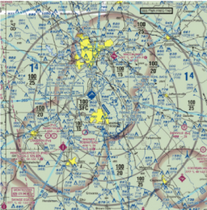
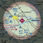
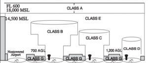
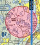
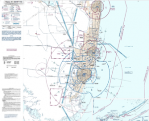
Class Bravo (B) is the next category and can be identified with large blue circles surrounding the area on sectional charts (see figure 1). The MSL ceiling (top) and floor (bottom) altitudes of each sector are shown in blue figures and like most aviation altitudes, have the last two zeros omitted (see figure 2). The airspace is often broken up into a variety of altitude sectors that are boxed off with blue lines. This means that 90/20 depicts that the airspace in that sector extends from 2000’ MSL up to and including 9000’. Floor altitudes that are proceeded by a “+” indicate that the airspace starts upward from above this altitude (i.e. +12 indicates that the floor is at 1201’). Operations at or below that altitude (1200’ in this case) are not included in Class B. Some Class Bravo airspace locations have particular requirements that are described in a blue box with blue letters (see figure 3). The name for the particular airspace will also be depicted ( for example).

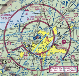
Class Charlie
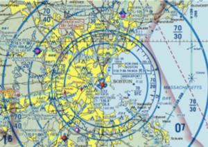
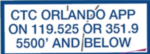
Identify Class Charlie (C) airspace with a magenta circle on sectional charts (see figure 4). Similar to Class B, Charlie altitudes are given in MSL with the last two zeros omitted, but they can be differentiated by their magenta color (see figure 5). If Class C airspace underlies Class B, the ceiling is depicted with a “T” for top which lies just under the beginning of the Bravo. SFC is a typical floor altitude stating the Charlie in that sector begins at the surface (see figure 6). The name of the Charlie is also given (i.e.,). Any specific regulations or notes are enclosed in magenta boxes and often include approach or control radio frequencies to be used by arriving aircraft to establish communication with ATC before entering Class Charlie (see figure 7). At some airports, the communication frequencies do not operate 24/7. To notify aircraft of this occurrence in this and other airspace classifications, the airport issues NOTAMs (notices to airmen) and/or has a published schedule in the Chart Supplement (previously known as the A/FD). When approach control closes in any airspace, that airspace reverts to class Delta, and without an active tower frequency, class Echo.


Class Delta
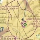
Surrounded by a dashed blue circle (see figure 8), Class Delta airspace has only one altitude number meaning it extends from the surface to that altitude that is shown in blue (see figure 9). A minus sign in front of the altitude indicates that Class Delta extends up to but does not include that height (see figure 10; -12 indicates Class D includes all airspace from the surface up to 1200’, but it does not include 1200’). This is common when Delta airspace underlies another airspace category such as Charlie.


Class Echo
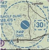
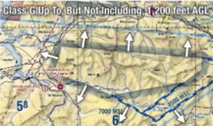
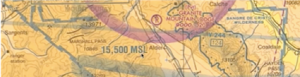
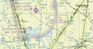
Perhaps the most misunderstood airspace category, Class Echo (E) starts at 14,500’MSL and extends up to but not including 18,000’ (bottom of Alpha Airspace) over the entire continental United States unless otherwise depicted. It also exists above Alpha (above 60,000’). In these cases, Class E airspace is not drawn on a sectional; however, Class Echo can start at other altitudes. If Class E begins at the surface, it is noted by a dashed magenta circle around the area (see figure 11). It can also start at 700’ AGL (shown in figure 12) in which case the airspace is drawn with a faded magenta ring. In locations where class E begins at 1200’ AGL (above ground level) the faded ring is blue (see figure 13). This is an interesting depiction because it states that everywhere outside of the faded blue shape (in the direction the arrows are pointing) class E starts at 1200’ AGL and only inside that small area (the direction the arrows are pointing away from) class E begins at 14,500 MSL. A better way to look at it is that Class E starts at 1200’ AGL everywhere except for inside the faded blue depiction or other examples given. If class Echo is designated to start at any other specific altitude, it is drawn with a blue zipper line (see figure 14).
Uncontrolled Airspace
Class Golf
Skipping a letter in the alphabet (Class Foxtrot airspace exist in other countries but not America), Class G airspace is considered uncontrolled, so the IFR requirements of communications, clearance, and a filed flight plan are not compulsory. This airspace is located where there is a lack of other airspace which is generally below Class Echo (less than 1200’AGL). Because this airspace fills in the gaps, it is not drawn on a sectional chart.
Rocket Ship Scenario
Speaking just in terms of identifying airspace by altitude, let’s take FD92 (Southerland- a private airport in Florida- see figure 15). If a rocket took off from this airport and flew directly up, we can identify all of the airspace classifications it goes through.
FD92 (Southerland airport)- assume the ground is at sea level
SFC- 1199 (G)
1200- 1299 (E)
1300-2999 (C)
3000- 10,000 (B)
10001-17999 (E)
18000-60,000 (A)
60,001- infinity (E)
We know that Class Golf lies below Echo which begins at 1200’ AGL unless otherwise depicted. The floor of Charlie is at 1300’ MSL and extends to T, or the bottom of the overlying Bravo which starts at 3000’ MSL. The ceiling of this airspace, shown in blue, is 10,000’ MSL and because nothing is depicted over it, we know Echo fills in the gap between 10,000’ and 18,000’ MSL where Alpha begins. Above Alpha again lies Echo.
2. Airspace Restrictions and Requirements
Entry Requirements
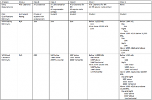
The image above depicts the various restrictions and requirements for each classification of airspace. To enter the airspace, if “ATC Clearance” is required such as for Alpha, Bravo, and Charlie and Delta for IFR traffic, the PIC (Pilot in Command) must establish radio contact with ATC (Air Traffic Control), and ATC must read back the call sign of that aircraft with the phrase “Cleared to enter Class ___ Airspace.” This is opposed to the “radio contact” requirement when all that is required is that the pilot and ATC establish two-way radio communication. In this case, ATC must simply read back the call sign of the aircraft (no clearance needed).
Pilot Qualification Minimums
Pilot qualifications become more rigorous with higher volumes of aircraft and more complicated airspace. Because Class Alpha is at such a high altitude and navigating with surface visual waypoints is nearly impossible, an instrument rating is required. Class Bravo involves some of the busiest airspace at the largest cities in the continent. A student pilot can fly in these locations on solo but requires a special endorsement and training provided by their flight instructor for this purpose.
VFR Visibility and Cloud Clearance Minimums
Class Alpha necessitates an instrument rating, so no visual and cloud clearance requirements are essential in this airspace. For other classifications of airspace, visibility requirements increase during the night. This is for the reduced visibility caused by a dark environment. Visibility requirements also tend to increase above 10,000’ MSL because, as noted later, above this altitude aircraft are authorized to travel at much higher airspeeds and need to see aircraft in time (which means at an increased distance) to see and avoid them in VFR (Visual Flight Rules). COC stands for Clear of Clouds.
Airspeed Restrictions
Below 10,000’ MSL, aircraft are authorized to travel at airspeeds up to and including 250kts. If an aircraft must go faster than this for normal operation to prevent stalls, they are permitted to travel at the lowest possible speed for that aircraft. The other exceptions to this rule are that below 2,500’ AGL and within four nautical miles of Class Charlie or Delta airspace, the maximum allowed speed is 200kts. Additionally, below a Class Bravo shelf (the airspace an aircraft is in isn’t Bravo, but airspace above that aircraft is), aircraft are restricted to 200kts. Above 10,000’ MSL, aircraft must maintain below Mach 1 unless special permission is attained.
Rocket Ship Scenario
Going back to the rocket ship scenario, we can now apply the altitudes, rules, and restrictions to the airspace overlying Southerland airport (we will assume the flight is conducted during the day).
| Types of Airspace | Entry Requirements | Min. Pilot Qualifications | VFR Visibility | VFR Cloud Clearances | Speed Resitrictions |
| SFC-1,199 G | None | Student certificate | 1sm | COC | 200kts |
| 1,200-1,299 E | None VFR | Student certificate | 3sm | 500 below
1000 above 2000 horizontal |
200kts |
| 1,300-2,999 C | Call sign | Student certificate | 3sm | 500 below
1000 above 2000 horizontal |
200kts |
| 3,000-10,000 B | Clearance | Student certificate w/ endorsement or private | 3sm | COC | 250kts |
| 10,001-17,999 E | None VFR | Student certificate | 5sm | 1000 above
1000 below 1sm horizontal |
Below Mach 1 |
| 18,000-60,000 A | Clearance | Instrument | N/A | N/A | Below Mach 1 |
| 60,001- Infinity E | None VFR | Student certificate | 5sm | 1000 above
1000 below 1sm horizontal |
Below Mach 1 |
3. Special Use Airspace
Special Use Airspace (SUA) restrict certain flight activities and entry to particular regions. They also caution other aircraft of activities that may occur in that airspace.
Special Flight Rules Area
Special Flight Rules Areas (SFRAs) have particular rules that might restrict certain kinds of air traffic. One example of this is over the Grand Canyon. This type of airspace is surrounded by a blue box with large teeth pointing inward (see figure 17).
Special Air Traffic Rules Area (SATR)
In these locations, additional rules and requirements must be followed by aircraft to pierce the airspace. These are commonly located at special Air Force bases and are shown as a white background with a blue surrounding both and teeth pointing inward (see figure 18). The rules will be located on the same chart in a separate box.
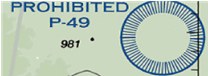
Prohibited Areas
Outlined in blue with blue teeth pointing inbound (see figure 19), prohibited areas separate certain airspace for reasons of national security or welfare. Their appearance is similar to that of restricted regions, but they are distinguished by a “P” followed by a number. These areas are permanently off-limits to general aviation. One example of this is the airspace over the White House.
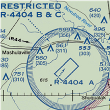
Restricted Areas
Restricted areas are also seen on sectional charts as a blue circle with teeth pointing inward, but they are identified by numbers following an “R” (see figure 20). The primary difference between the previous SUA and this one is that restricted areas do not entirely prohibit flight activity. An aircraft must be authorized to enter this airspace by ATC and recognize dangers such as artillery fire, gunnery, and guided missiles. These areas can be “hot” or “cold” referring to active or non-active, respectively. Sectional chart legends and Chart Supplements provide the times and altitudes for this and other airspace classifications. When they are non-active, aircraft can fly through restricted areas without requesting permission.
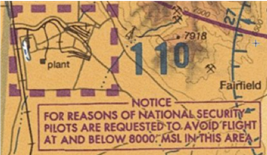
National Security Areas
In other locations, pilots are requested to maintain above a certain altitude for national security reasons, but these areas do not require the extent of protection needed to permit restricted airspace. These areas have thick, dashed magenta lines (see figure 21). Area 51 might be a good example.
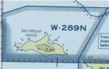
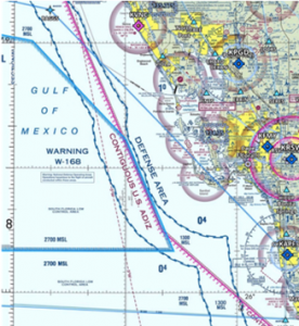
Warning Areas
Warning areas are located offshore to advise aircraft that they may be entering a location of hazardous activity. Identify these locations with numbers following a “W” and a drawing similar to that of prohibited and restricted areas (see figure 22).
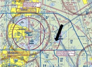
Alert Areas
Located in regions of irregular aerial activity or dense pilot training, alert areas warn pilots of additional hazards. These areas have no special rules and are depicted with a red line with red teeth pointing inward and numbers following an “A” with the related hazard noted (see figure 23).
Military Operation Areas
Military Operation Areas (MOAs) are designated to separate fast, military aircraft from IFR traffic. VFR traffic can enter freely but should be aware of combat training, formation flights, and in-air refueling aircraft as well as military aircraft flights at night without lights. For extra diligence and situational awareness, VFR flights through this area can ask for flight following or monitor the controlling ATC agency. These appear similar to alert areas but with “MOA” as the identifying factor (see Figure 24).

Temporary Flight Restrictions
Temporary Flight Restrictions (TFRs) prohibit aircraft from entering a specified airspace for a specific time period. Reasons for this can be anything from the President visiting the area to Disneyworld fireworks. The locations for these areas are not typically drawn on paper sectionals as they are temporary, but information concerning times, altitudes, and locations can be found in NOTAMs of surrounding airports, and certain flight planning apps (such as Foreflight) can depict these areas in red (See figure 25).
4. Routes and Transitions
Military Training Routes (MTRs)
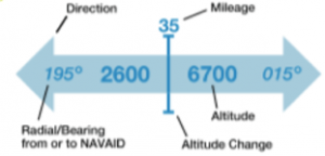
MTRs identify locations where heavy concentrations of military traffic are found. IR indicates IFR routes and VR indicates VFR routes on the long gray lines (see figure 26). For traffic at and below 1500’ AGL, IR or typically VR is followed by 4 numbers. For flights above 1500’ AGL, the route has 3 or fewer digits.
VFR Transition Routes
VFR Transition Routes are found in a TAC (Terminal Area chart- depict certain Bravo airspace with further detail) and indicate a specific flight course for VFR traffic to follow to transition around or under Class Bravo airspace. These include the specific altitudes to follow and the course that will provide the least delay for ATC. A pilot must receive clearance before flying a VFR transition route (see figure 27).
VFR Flyway
A flyway is similar to a transition route in that both are shown on a TAC and both help VFR pilots avoid Class Bravo Airspace. These are suggested routes that do not require ATC contact (see Figure 28 and 29).
VFR Corridors
A corridor helps aircraft transition through Class Bravo airport by cutting a hole in the Bravo with specific lateral and vertical restrictions through which VFR traffic can fly without clearance or communication with ATC. These are shown on regular sectional charts (see Figure 30).

5. Other Airspace
Mode C Veil
You may have noticed earlier the Mode C circle surrounding Class B and C locations (see figure 31). In these areas (as well as above and below this airspace) and above 10,000’ MSL (unless below 2,500’ AGL), a transponder with at least mode C capabilities is required. This type of transponder transmits the aircraft’s location and altitude to ATC along with a specific “squawk” code to help identify the aircraft.

Air Defense Identification Zones (ADIZ)
Each country owns the airspace directly above it, but international waters are governed by international law. To separate American airspace from international air traffic, ADIZ marks the distinguishing line between the two with a magenta mark and dots (see figure 32).
Terminal Radar Service Areas (TRSA)
TRSAs are few and far in-between nowadays but are still found in some locations and are depicted with gray circles (see figure 33). These areas surround a Class Delta airport and provide radar services (such as assistance in traffic avoidance) to participating aircraft but are not busy enough to be categorized as Class Charlie and thus do not require clearance to enter or a Mode C transponder.