-
Why do we need ILS?
-
What information does ILS provide?
-
What equipment do you need on the aircraft?
- Course Deviation Indicator
- Horizontal Situation Indicator
- Marker Beacon Lights
- Other Equipment
-
What equipment does ILS need on the ground?
- Localizer
- Glideslope
- Marker Beacons
- Approach Lights
- Distance Measuring Equipment
- Compass Locators
-
What are the Categories of ILS?
-
What’s the Back Course?
-
ILS Signal Interference
-
Limitations of the ILS
-
Marker Beacon Limitations
-
What Mistakes Do Pilots Make With the ILS?
-
What Happens When the ILS is Inoperative?
-
How to Fly an ILS Approach
- Preparing for the Approach
- Getting Established on the ILS
- Descending to the DH
- Breaking Out
-
How to Make the Autopilot Fly an ILS Approach
- Back Course Approaches
- Autopilot Limitations
-
The Future of ILS
-
Conclusion
Even driving a car can be dangerous in foggy weather. So how do pilots manage to land their aircraft safely and accurately without even being able to see where they’re going?
Unlike your car, most aircraft are able to use a navigational system called the ILS.
The ILS uses radio signals to help pilots align the aircraft accurately on their approach to a runway.
Why do we need ILS?
If aircraft were limited to landing only when the weather was perfect, we would be flying a lot less than we do now!
There are specific procedures published for each runway that tell pilots how to use the ILS for that particular runway. When you’re following one of these procedures to line yourself up for landing, you’re said to be flying an ILS approach.
Instrument approaches allow you to descend to the runway even if the visibility is poor at your destination because of fog, rain, or clouds.
There are two kinds of Instrument approaches: Precision and Non-Precision.
Non-precision approaches only provide lateral guidance. They’ll line you up with the runway but won’t tell you if you’re too high or too low on your approach.
Since the ILS provides vertical as well as horizontal guidance, ILS approaches are classified as precision approaches.
When you’re flying a non-precision approach, you can’t descend below the Minimum Descent Altitude (MDA) until you’ve made visual contact with the runway. That means you descend on your approach down to the MDA, level off, and then maintain altitude until you see the runway.
If the visibility is very low, you might not be able to see the runway until you get very close to it. That won’t leave you with enough time to descend safely, and you’ll have to go around.
Precision approaches, however, allow you to descend continually until you reach a Decision Height (DH). The vertical guidance lets you know what the right glide path is, so you have better situational awareness and know exactly where you are in relation to the correct glide path.
The ILS provides a safe and reliable navigation system that can aid you in your visual landings or even allow you to land in situations where it would be impossible to do so visually.
What information does ILS provide?
There are three types of information given to the pilot by the ILS. They are:
Guidance information: Given by the localizer and glideslope. These help the pilot align the aircraft properly with the runway for landing. The localizer provides lateral or horizontal guidance, letting the pilots know if they need to turn left or right to correct their course. The Glideslope gives vertical guidance, letting the pilots know if the aircraft is too high or too low on the approach.
Range information: This is provided by the Marker Beacons, DME, and GPS. This information tells the pilot the distance remaining to the runway. The pilot uses this range information to verify that the aircraft is flying at the right height for that section of the approach. Range information is also used to adjust the aircraft configuration and prepare the aircraft for landing. Lowering flaps, extending the landing gear, and making the final decision to land or go around are all tied to the distance remaining to touchdown.
Visual information: This is given by the Approach Lighting System. Approach lights help the pilot transition from instrument flying to flying visually for the very last part of the approach.
What equipment do you need on the aircraft?
The localizer uses radio frequencies just like a VOR does, so all you need are standard VHF (Very High Frequency) radio receivers. The glideslope requires a UHF (Ultra High Frequency) receiver. The instruments that can display the signal readout to the pilot are the CDI and the HSI.
Course Deviation Indicator
The CDI stands for Course Deviation Indicator. This instrument features two moving needles, one vertical and one horizontal, that show the deviation from the Glideslope and Localizer courses respectively.
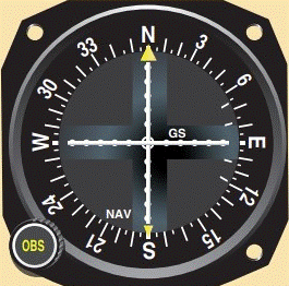
The CDI does not provide any heading information. It just shows the aircraft’s position relative to the reference marks on the selected course to or from a station. You can select the course you want to track using a knob known as the Omni Bearing Selector (OBS).
As soon as it picks up the signal, the needles in the CDI will be displaced from their center position. The displacement of the needles shows the corrections you need to make to your bank and attitude in order to intercept the right course.
For example, if the needle shifts to the right, you need to fly right in order to re-center it. Similarly, if the needle displaces itself upward, you need to climb to intercept the correct glide path. This is called ‘following the needle’.
When the needles are overlaying the reference marks, the aircraft is aligned with the runway and flying on the glide path. The CDI has divisions between the mean position and the full deflection position. This scale shows how far off course you’re flying.
Some models of CDIs, such as the one in this diagram, are only designed to function as VOR receivers. They will pick up localizer signals but don’t show any vertical deviations and as a result, can only be used for non-precision approaches.
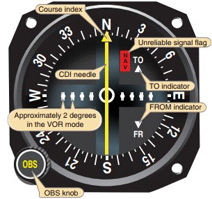
When the CDI is tracking a VOR, the full-scale deflection represents 10 degrees. The localizer is designed to be more sensitive than a VOR, and the Glideslope is even more sensitive.
The full-scale deflection for the localizer is just 2.5 degrees and the GS has a 0.7-degree maximum deflection. For a 5-dot CDI, each horizontal division represents 0.5 degrees of deviation on one side. Any deviation greater than 2.5 degrees will still be shown as 2.5 degrees on the CDI.
There’s no way to know just how far off course you are once the needle hits the full-scale limit. This uncertainty in the final deviation mark is why pilots disregard full-scale deviations. The FAA instrument rating standards only allow a maximum CDI deflection of three-quarters of the scale on the final approach.
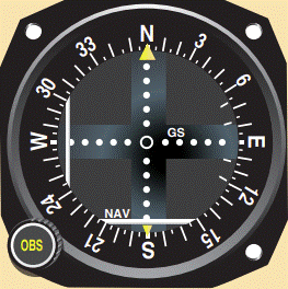
If the CDI loses the signal from a VOR or ILS or is inoperative, it displays a warning flag that indicates you can’t rely on any reading shown by it.
Horizontal Situation Indicator
The HSI stands for Horizontal Situation Indicator. The major difference between a CDI and an HSI is that the HSI has a heading indicator built-in, unlike a CDI. The operation of the HSI is generally the same as that of the CDI, but the addition of heading information offers greater situational awareness for the pilot.
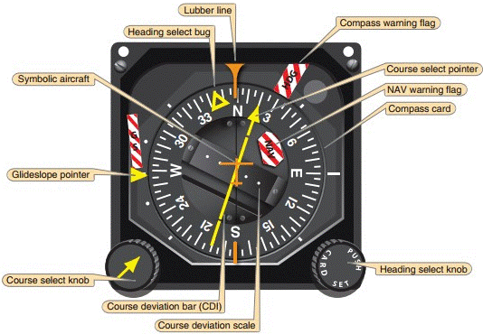
The ILS frequency is selected in the NAV radio in the same way as you would for a VOR station. Unlike tracking a VOR though, you don’t need to set any course with the OBS knob for a CDI to track the localizer.
You can track any radial inbound with a VOR station, but localizers will only guide you along the one track published in the approach plate for the ILS. Setting the correct course is more important if you’re using an HSI since it affects the direction of the course select pointer.
With that said, it’s good practice to set the OBS to your inbound course anyway, as it helps aid your situational awareness.
Marker Beacon Lights
The Marker Beacon lights are three separate lights installed on the radio stack on the instrument panel.
The Outer Marker Beacon has a blue light, the Middle Marker an amber light, and the Inner Marker has a white flashing light on the instrument panel. They are labeled O, M, and I respectively.
The Marker Beacon receiver can be switched to high or low sensitivity modes. Pilots use the high sensitivity setting to get an advance warning of the approaching beacon. Then they switch to the low sensitivity setting to make sure they’re directly overflying the beacon and are exactly on course for their approach.
Other Equipment
Other airborne equipment includes the ADF and DME instruments, in addition to receivers installed for each system. ADF uses low to medium frequency receivers and DME requires a UHF receiver.
What equipment does ILS need on the ground?
The ground-based radio equipment at the airport includes the Localizer and Glideslope antennas and their transmitter buildings.
The visual part of the system includes the Approach Lighting System and VASI or PAPI lights.
The marker beacons are on the extended centerline of the runway but are placed at a significant distance away from the airport. Each runway with ILS will have two to four marker beacons each.
Localizer
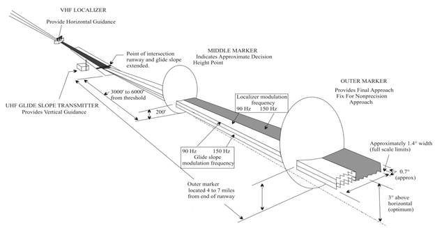
The localizer is a radio transmitter placed at the departure end of the runway along the extended centerline. It uses two radio beams that are transmitting at distinct frequencies.
One of the beams is aimed at one side of the runway at a modulating frequency of 90 Hertz. The other beam is aimed at the other side of the runway, transmitting at 150 Hertz.
This means that when you’re exactly on the runway’s centerline, you should be receiving both modulated beams with equal intensity.
The beams are intense enough that your aircraft can pick them up to 18 nautical miles away! They’re designed to be directional, so you can’t detect them at heights greater than 4,500 feet. The operational service area of the localizer is shown in the diagram below.
The width of the beam is also designed to be narrow. The localizer course signals are sent out in just a 5-degree area. This means that the signal received by the aircraft will be very sensitive, allowing the pilot to notice even slight variations in the course.
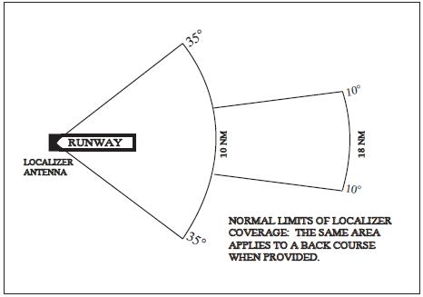
The aircraft’s receiver will show a full-scale deflection if the aircraft is only 2.5 degrees off of the centerline. Because of the high sensitivity, even keeping the aircraft within a quarter-scale deflection means that you’ll be aligned with the runway.
Each localizer has a published frequency that it uses to transmit its signals. Localizers can be allotted any frequency that has an odd tenth digit within the range of 108.1 Megahertz and 111.95 Megahertz. Only a total of 40 possible localizer frequencies are available.
If you’re going to rely on the localizer as the primary navigational source, you need to make sure you’re tuned in to the right localizer. Every localizer station has a three-letter designation, with the letter I preceding it to identify it as an ILS. Each station transmits its identification code in Morse Code at regular intervals. You should always listen to the identifier whenever you tune in an ILS frequency to verify you’re following the right localizer, especially at airports with parallel runways.
Glideslope
The Glideslope (GS) is the system that provides vertical guidance along the glide path. The glide path is the angled straight line that leads the aircraft down from the Final Approach Fix (FAF) to the runway at a controlled rate of descent.
In contrast to the localizer, the GS is housed in a building near the approach end of the runway. The frequency range for the Glideslope is 329.3 to 335.0 Megahertz which is part of the Ultra High Frequency (UHF) bandwidth.
You don’t have to tune the GS frequency manually though. When you tune a localizer frequency, the receiver tunes in the paired GS frequency automatically.
The Glideslope functions in a similar manner to the localizer. It also has one beam transmitting a modulating frequency at 150 Hertz and the other at 90 Hertz, but in this case, the arrangement of the beams is vertical.
If you’re flying too high or too low on approach, the signal intensity of one of the beams will be greater, and the aircraft’s onboard instruments will show a deflection. Only when the pilot is flying correctly on the glide path will both the signals have equal intensity and the needle will be centered on the pilot’s instruments.
The standard glide path has an angle of 3 degrees, although some runways have steeper approaches due to terrain or obstacles. The most famous steep approach is at London City Airport, with a glide slope of 5.5 degrees to avoid the high-rise buildings in the area.
The Glideslope is generally adjusted to project at angles between 2.5 to 3.5 degrees above the horizon. The thickness of the glide path beam is around 1.4 degrees, which translates to a vertical distance of just a few feet at the threshold and over 1,500 feet at 10 Nautical Miles from the runway.
Glideslope signals are typically only reliable till the 10 Nautical mile mark from the threshold. Only some approaches are certified for an extended service volume, which means that they’ve been tested to generate reliable signals at a greater range.
If you’re following the Glideslope perfectly, it leads you to a height of 50 feet when crossing the threshold. From that point onwards you can use visual references to flare the aircraft and slow the descent for the touchdown.
Marker Beacons
Marker Beacons are small, low-powered radio stations transmitting on VHF and are a part of the ILS. Two beacons are standard in every ILS, the Outer Marker (OM) and the Middle Marker (MM).
The OM is usually found around 5 to 7 miles from the runway. It’s placed that far out because it’s meant to be the point where the aircraft intercepts the glide path.
The MM is placed one nautical mile from the runway threshold along the extended runway centerline. When the aircraft passes the MM, it’s supposed to be at a height of 200 feet from the runway elevation.
For aircraft flying a Category I ILS, the height of the aircraft at this time is called the Decision Height (DH). Aircraft descending through DH must decide whether to continue with the landing or go around if they’re not stable on their approach.
Some ILS systems also have the third beacon. It’s called the Inner Marker (IM) beacon and it’s placed between the MM and the runway threshold.
The IM serves as the point marking the Decision Height for aircraft flying a Category II ILS.
As the aircraft flies over a beacon, the corresponding marker beacon indicator blinks on the aircraft’s instrument panel and you can hear the beacon alert on your headset.
These days, the use of Marker Beacons has largely been replaced with DME and GPS.
Approach Lights
Radio navigational guidance is all well and good, but the part of the approach where you’ve found your way to the runway and are on short finals has to be flown visually. The localizer and glideslope indications become very sensitive the closer you get to the runway. If you’re relying on radio navigation on short finals, it’s easy to make an overcorrection that messes up the approach right at the end.
It’s the transition from instrument to visual flying that’s the trickiest part of low-visibility flying. This is where the visual component of the ILS comes into play.
ALS
The Approach Lighting System (ALS) is a set pattern of lights that help the pilots orient themselves on short finals. The lights are fairly powerful and distinctive, so you can see them in heavy fog or rain and can differentiate them from city lights or other distractions in the vicinity.
There are a few varieties of ALS configurations, some of the most common ones are shown in the diagram below.
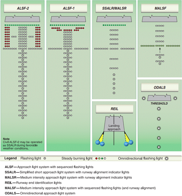
The sequenced flashing lights shown in the diagram have a nickname- the Rabbit. These lights flash in a synchronized way, making a moving ball of bright light that moves rapidly towards the runway. This pattern is designed to catch the pilot’s eye and point out the threshold, which is useful in very low visibility.
The lighting configuration for every runway is provided in the approach plate so that you know what to look out for and can positively identify you’re lined up with the right runway. This is especially useful for airports that have multiple runways.
VASI and PAPI
Similar to the ALS being the visual equivalent of the localizer, the VASI or PAPI lights are used in place of the Glideslope when you’ve switched to visual references in preparation to land.
VASI stands for Visual Approach Slope Indicator and PAPI is the Precision Approach Path Indicator. Both these lighting systems operate the same way. The VASI system has two to eight pairs of light bars arranged along the side of the runway as shown in the diagram.
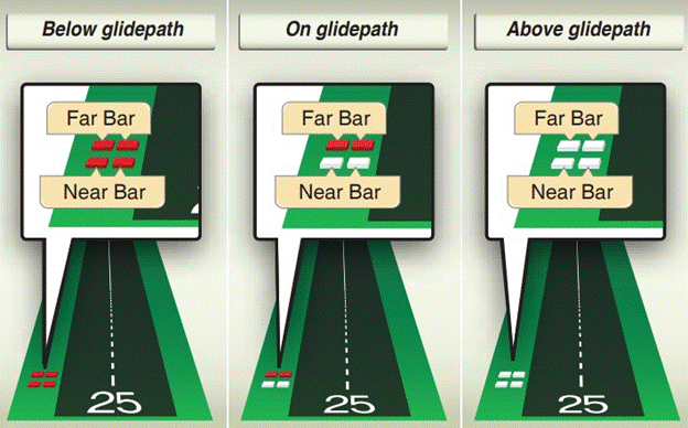
If you’re flying too low on your approach, all the indicators will appear red. Conversely, if you’re too high, you’ll see them as all white. When you’re following the glide path correctly, you’ll see the lower indicators showing red and the upper indicators showing white.
The PAPIs use the same red and white concept but have four indicators arranged in a single line. The PAPIs show you two red and two white lights if you’re flying on the glide path. You can use these indicators even without following an ILS.
The glide path that the PAPIs and VASIs guide you to is usually coincident with the glide path from the GS. Because of the extreme sensitivity of the GS close to the runway, it’s best to switch to the VASIs or PAPIs as soon as you’re visual with them.
Distance Measuring Equipment
The DME system is not explicitly part of an ILS system but it is commonly used by pilots when flying an ILS approach. DME stands for Distance Measuring Equipment, and as you can tell from the name, this system provides range information just like the marker beacons.
DME is often co-located with a VOR transmitter, making the combined unit a VOR/DME or VDME.
Approaches that use DME have the words ‘DME Required’ written on the approach plate.
Marker beacons only provide range information at the fixed intervals where they are installed whereas the constant supply of range information by the DME gives the pilots greater situational awareness.
In fact, some airports have replaced beacons with DME entirely. While they’re not entirely obsolete yet, no new middle marker beacons are being installed by the FAA.
Compass Locators
Compass Locators are another supplementary system for the ILS. They’re actually a type of Non-Directional Beacon transmitters or NDBs that are used with the marker beacons in an ILS.
Signals from the Compass locators are compatible with Automatic Direction Finding (ADF) receivers. A predecessor of the ADF used to be called a radio compass, and that’s where the compass locator’s name comes from. Like general NDBs, compass locators are virtually obsolete these days, but you might still come across one on an approach plate.
Compass locators are almost always placed in the same location as the Outer Marker beacon and are shown as a LOM or Locator Outer Marker on approach charts.
They can also be found at the Middle Marker, with the combined unit called an LMM or Locator Middle Marker.
Compass locators use a two-letter identifier that uses part of the three-letter localizer’s identification.
Compass locators guide the aircraft from the en-route NAVAIDS to the ILS, though the now-common use of GPS has rendered them obsolete.
What are the Categories of ILS?
The conditions that allow the use of an ILS approach vary with the equipment installed on the runway, the equipment available on the aircraft, and the pilot’s certification.
The differences between the ILS types are based on the visibility along the runway (known as the Runway Visual Range or RVR), and the Decision Height (DH).
Higher categories of ILS allow landing in low RVR and have a reduced DH, which means they allow you to land in worse visibility and permit going lower before having to make the decision to continue or abort the approach.
- Category I approaches has a minimum RVR of 1800 feet and a DH of 200 feet above the runway.
- Category II approaches reduce the minimum RVR limit to 1200 feet and the DH to 100 feet.
Category III is divided into three sub-types.
- Category IIIA allows landing with a 700 feet RVR and a DH less than 100 feet.
- Category IIIB reduces the allowable RVR to only 150 feet and the DH to 50 feet.
- Category IIIC is a special type of ILS approach that has no RVR or DH limitations at all!
The list above isn’t exhaustive; some special authorization ILS categories permit landings with reduced runway lighting or allow landing under reduced RVR with equipment such as a Heads Up Display installed on the aircraft.
The CFRs related to the equipment needed for an aircraft to be eligible for Category II approaches can be found here. Generally speaking, Category II approaches require two certified pilots, two sets of flight instruments, and two independent navigation radios.
14 CFR § 61.3 parts (f) and (g) spell out the requirements that flight crews have to meet before they can fly Category II and Category III approaches respectively.
While Category I approaches can be flown by most IFR-rated aircraft and flight crews, the very low minimums of the higher category approaches are usually flown with the autopilot.
Category IIIA aircraft need to have an autothrottle system and an auto-land capability. Category IIIB aircraft are required to be able to not just land but also control the aircraft through the landing run and bring it to a stop.
The reason for these restrictions is that because of the very low DH, the pilots won’t have enough reaction time available to make corrections in case they go off course.
Category IIIC approaches are currently not operated anywhere. Even though the aircraft might be capable of landing with zero RVR, there’s no safe way for the pilots to taxi out and go to the ramp without seeing where they’re going.
Category II and III also have other requirements for airports such as holding points on taxiways placed further away from runways to reduce the chances of signal interference. The radio transmitters themselves need to have backup systems and are repeatedly monitored to make sure they are operating normally.
What’s the Back Course?
Some ILS units transmit signals in the opposite direction (i.e the departure end) as well. This course is called the back course while the signals sent along the approach end are called the front course of the ILS.
Back courses are useful for airports that don’t want to spend a lot of money to install an entire ILS system on the other end of the runway which might not get as much use. The back course can be used by aircraft as a navigational aid, but there are some significant differences between ILS operation on the front course versus the back course.
Firstly, back courses do not get any glide path information. The GS only transmits on the front course, and the lack of vertical guidance on the back course makes it a non-precision approach.
The second major difference is the way the localizer signals are shown on the aircraft’s instruments when it is flying along the back course.
As described above, when flying the forward course your aim is to center the lines on the CDI to align yourself properly on the approach.
While the basic premise is the same; aligning the lines with the marks in the center, the movement of the CDI needles on the back course happens opposite to the way they do in ILS approaches on the front course. It’s called reverse sensing and it means that if the localizer needle indicates the path is towards the right, you’ll need to turn left to get back on course!
Confusing?
That’s understandable. Following the localizer needle to get back on course is such an ingrained action for instrument pilots that it takes constant conscious effort to remember you’re flying a back course approach and the readings are reversed.
You can make back course approaches easier for yourself if your aircraft is equipped with an HSI. All you need to do is set the front course for the localizer using the OBS knob. You can then go on and fly towards the needle as you would while flying the front course.
You should not be flying a back course approach unless one has been published for the specific ILS you’re flying and you’ve been authorized by ATC to fly the back course.
If the runway has a back course marker installed, that point indicates the Final Approach Fix for the approach. This is the point where the aircraft commences its approach descent.
Flying over the back course marker lights up the white indicator light on the instrument panel. Because of the lack of vertical guidance from the GS on the back course, the pilot has to either use an alternate source or fly the descent profile published in the approach chart.
Another difference between approaches to the front and back courses is that the missed approach point for the back course is located a long way from the runway threshold.
The reason for this is that the localizer array is placed on the closer end of the runway from your perspective on the back course.
Since localizer signals are very sensitive at short distances, it would be very difficult to stay on course during your missed approach on a back course.
ILS Signal Interference
Surface vehicles or aircraft can disrupt ILS signals significantly. As the localizer is transmitting from the departure end of the runway, and the GS from a location offset to the runway, the presence of any large metal conductor (which is what aircraft bodies are) is going to interfere with signals in between the transmitters and the receiving aircraft on final.
All ground-based components of the ILS are positioned in places where the chances of interference are minimized, but their placement can be constrained by obstacles and terrain surrounding the airport. You can look at the criteria that the FAA uses when placing ILS equipment here.
Since signal interference is known and predictable behavior, airports have ‘protected’ certain areas of the airport when the ILS is active. These critical areas are monitored by ATC and taxiing aircraft are advised to hold short at specially marked lines while an aircraft has passed the Outer Marker on its approach.
The problem is that these protected areas are only active when the visibility is less than 2 miles or the cloud ceiling is less than 800 feet.
You can still use the ILS for navigational guidance in good visibility but the controller will advise you whenever ILS protected areas are not in operation. The protection also doesn’t cover aircraft that have just landed or departed.
When the approaching aircraft passes the Middle Marker, all vehicles are prohibited from the protected area as long as the RVR is less than 2,000 feet or the cloud ceiling is less than 200 feet.
You might be wondering how the critical areas are protected at uncontrolled airports.
The answer is that they aren’t. Pilots need to constantly monitor the localizer and GS signals and be on alert to take corrective action whenever they’re on an ILS approach to an uncontrolled airport.
Even the presence of smaller vehicles such as a lawn mowing tractor near the runway has been known to cause signal disruptions.
Malfunctions in the aircraft’s receivers can also cause variations in the readings shown on the CDI or HSI. You can verify your aircraft’s equipment by cross-checking it with another ILS receiver.
If you encounter unreliable ILS signals on your approach, use alternative guidance sources or execute a missed approach.
Limitations of the ILS
As the ILS and its components are radio-based systems, they share weaknesses that are common with other radio transmissions.
The first limitation of the ILS is that transmissions from the Localizer and Glideslope bounce as they reflect from hard obstacles. This includes terrain, surface vehicles, and even other aircraft in the vicinity.
The second problem associated with ILS signals is false courses. ILS signals are designed to be highly directional. Even so, it’s not feasible to block all errant transmissions from the system given the high power that’s needed for the signals to reach all the way to the Outer Marker.
False courses exist in GS transmissions above the real glide path and create an entirely separate course at a glide path of 9 degrees. The pattern of false courses continues at 12 and 15 degrees.
Some GS transmissions even have reverse patterns in between each false course. In these areas, the signals will tell the pilots to descend when they’re below the false glide path and climb when they’re above it – the opposite of what it’s designed to do.
Aircraft that mistakenly intercept a false course would be led downwards at a dangerously steep approach angle and would encounter fluctuating and unreliable signals all the way down.
This is why pilots need to ensure they’re not flying above the altitude published on the approach chart at the time they intercept the GS. False courses don’t exist below the true glide path since they get blocked by the ground. It’s always recommended to intercept the GS signal from below the glide path.
You might also encounter false courses from the GS when flying on the back course as well. Never rely on them, and always remember that vertical guidance is not provided by the GS on the back course unless a GS is explicitly mentioned on an approach chart.
The localizer also shows false courses at wide angles from 40 to 60 degrees from the landing course. No warning flag will be shown on the CDI or HSI and for all intents and purposes, it’ll look like you’re flying on course. You should disregard all localizer readings when the aircraft is not in the published localizer coverage area.
Marker Beacon Limitations
Marker beacons are low-powered by design. They’re only supposed to trigger the aircraft’s instruments when you’re flying directly overhead them at the correct height, so having too powerful a beacon would be a bit counter-intuitive.
But if the aircraft’s receivers are not sensitive enough, it’s possible for them to miss the beacon even when the aircraft is on course.
Another reason for not receiving the beacon’s signal is that the pilot might not realize that the aircraft receivers aren’t turned on. Some aircraft don’t have a dedicated power source for the beacon receivers and instead are supplied power via another radio system such as an ADF receiver.
ADF systems are practically obsolete these days so it’s not unusual for pilots to keep the ADF off. If your aircraft is not picking up marker beacons, check if they depend on another system that you might not be using.
In some aircraft, there’s no real way for the pilots to know if the beacon receivers are even functioning without flying over an actual beacon. The TEST indicators on the system are usually only designed to test if the light bulbs are working – not the receiver itself.
Even if you’re flying visually, it’s not a bad idea to tune in to the ILS periodically just to verify your system can pick up the marker beacons.
What Mistakes Do Pilots Make With the ILS?
The ILS is a very reliable and accurate navigational aid. Most mistakes made by pilots are the result of a lack of knowledge of how it works and the limitations of the system.
Since the aircraft shows the ILS indications on the same equipment and in the same manner that it does for VOR signals, pilots often assume that the behavior of the indications will be identical in both cases. In reality, localizer indications are more sensitive than what unprepared pilots might be expecting. This leads to overcorrections by the pilots and an unstable approach.
Another reason for unstable approaches is pilots getting disoriented and intercepting the localizer at a very wide angle. You should always aim to intercept the localizer with as shallow an angle as is feasible to avoid catching a false course.
Always remember that the full-scale deflection reading should always be disregarded. The instrument will show a full-scale deflection for any reading beyond the scale, so you would not be able to know just how far off course you are just from looking at the CDI or HSI.
Chasing the needles is also something that leads to an unstable approach. The pilot should anticipate the movement of the needles and limit adjustments to ensure a smooth approach.
A major mistake is neglecting to identify the ILS positively. You don’t want to line yourself up with some other runway. That mistake could prove to be embarrassing at best and fatal at worst.
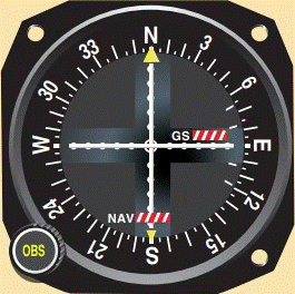
Following inoperative ILS signals can lead to disaster. If there’s a NOTAM alerting pilots that the ILS is inoperative, pilots should never follow any signals they receive.
Following an errant signal believing it to be transmitted by an inoperative ILS was what brought down a Boeing 747 operating Korean Airlines flight 801 at Guam in August 1997.
While inoperative NAVAIDs usually stop transmitting their identifiers, in some cases the identifiers may still be transmitted while it is being tested or repaired. You should always rely on the NOTAMs and should not follow signals from a NOTAMed NAVAID, even if it is transmitting.
What Happens When the ILS is Inoperative?
When the glideslope is non-operational, the approach can be flown using only the localizer. The absence of vertical guidance turns it into a non-precision approach.
Localizer approaches have greater minima than ILS approaches but have lower minima than VOR approaches. Lower minima mean that the approach allows landing even in reduced visibility.
If the localizer is out of service, an ILS approach cannot be carried out.
How to Fly an ILS Approach
Preparing for the Approach
As you’re flying towards your destination, tune into the ATIS when you get within range to find out the runways and approaches in use at the airport.
ATC will advise you about the approach you should be expecting. If your aircraft is equipped with a GPS or FMS unit, you can load the approach into the system.
Prepare for the ILS approach by studying the relevant approach plate. You should note the runway length and elevation, plan waypoints along the route, preload the radio frequencies you’ll need, and study the missed approach procedure.
You should also take note of the available NAVAIDs on your approach, the type of ALS installed at the runway, and the approach minima described on the approach plate.
Keeping track of active NOTAMs will let you know if any of the ground equipment is out of service.
Getting Established on the ILS
You’ll proceed to the Initial Approach Point (IAP) and follow the chart to the Intermediate Fix (IF) or get vectored for the final approach by ATC.
As you come closer to the Outer Marker, you’ll come into range of the localizer signal. Plan your approach to intercept the localizer within 30 degrees of the runway course to prevent catching any false courses. Tune in to the frequency and listen to the identification code to positively identify it.
The CDI will come alive and the NAV or LOC warning flag will go away as it captures the localizer signal. Use the indications to line up to the runway course by centering the needles.
Remember, if you’re flying the back course, the CDI will be reverse sensing and there won’t be any GS signals unless explicitly mentioned on the chart. If you’ve got an HSI, adjust it to the front course.
When the aircraft passes the Outer Marker, the Blue indicator labeled O will flash and you’ll hear the identification tone in your headset. This is the point where the aircraft should intercept the Glideslope.
The GS intersects the Outer Marker at a height of around 1,400 feet above airport elevation. Remember that you should ideally be intersecting the GS from below in order to avoid intercepting a false course. On the other hand, you need to also keep in mind that flying too low will put you in danger of collisions with obstacles on the ground.
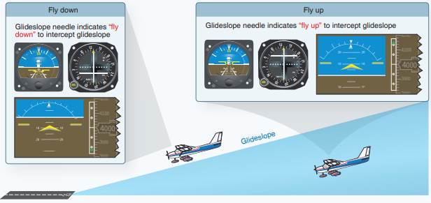
The GS indications should be close to the mean position on your instrument. Centering the needle will put you exactly on the glide path. At this point, you can advise ATC that you’re fully established on the ILS.
ATC will hand you over to the control tower which will be giving you your landing clearance.
Descending to the DH
If you’re flying a Category I ILS, the Middle Marker is the point where you are at your Decision Height. You’ll hear the marker on your headset and you’ll see the amber indicator labeled ‘M’ blink.
At this point, the GS will typically guide you to be at a height of 200 feet above the runway. You should determine if you’re flying on course and if your approach is stable or not. If something looks wrong, go for a missed approach.
You can fly the approach down to the Inner Marker before making your decision if you’re flying a Category II ILS.
Monitor the Localizer and GS signals throughout your descent to ensure you’re not receiving signal interference or course distortions. You can double-check your approach using a secondary navigation source such as GPS.
Breaking Out
The final stage of the approach when you make visual contact with an airport reference is called ‘Breaking Out’. The Approach Lighting System should come into view and you can shift from radio navigation to visual references.
You should positively identify the type of ALS with the pattern shown on the approach chart to make sure you aren’t mistaking any other light source for the runway. The VASIs or PAPIs should come into view with two red and two white lights for an aircraft on a good approach.
At this point, the approach should be flown using only the visual guidance from the lights: lateral guidance from the ALS and vertical guidance from the VASI or PAPIs.
The most common mishap on approaches that break out late is that the pilots have a rough idea of where the runway is, but haven’t been able to identify the threshold. This can lead to landing long on the runway.
Landing too far down the runway runs the risk of not having enough room to bring the aircraft to a complete stop. Make sure you positively identify the runway threshold, not just the runway edge lights
Take care not to hit your wheels on the Glideslope antenna on your way down! Aim for a safety margin clearance of at least 20 to 30 feet between the wheels and the antenna array.
How to Make the Autopilot Fly an ILS Approach
Using the autopilot to fly the ILS is called flying a coupled approach. The autopilot is tied into the signals received by the CDI and makes adjustments to follow the localizer and GS perfectly.
As you tune in the ILS frequency and fly up to the Outer Marker, you’ll notice the localizer needle come alive on the CDI. Pressing the NAV or LOC key on the autopilot commands it to follow the needle and line you up with the approach. This is known as the Localizer Hold or Nav Hold function on autopilots.
Once you’re lined up past the Outer Marker and the GS needle is alive, you can press the APR, APP, or GS key on the autopilot to command it to follow GS signals as well. This function is called the Approach Hold command.
The autopilot supports ‘arming’ the Localizer Hold and the Approach Hold functions. Arming the system means that the autopilot will operate in Heading Hold and Altitude Hold modes until the CDI comes alive. After receiving a strong ILS signal, the system automatically activates the Localizer Hold and Approach Hold functions.
Most autopilots don’t allow the Approach Hold function to be armed unless the Altitude Hold and Localizer Hold modes are already active.
It’s good practice to turn the APR key sometime after pressing the LOC key. You should transfer glide path control to the autopilot only when you’re certain the aircraft has captured the correct GS signal and you’re not following a false course.
Coupled approaches relieve the pilot of manipulating the controls to follow the highly sensitive ILS signals, but they don’t turn you into a passive bystander.
You should remember that the ILS is vulnerable to course deviations and poor signals and so you should always be ready to disconnect the autopilot and take over the controls.
Back Course Approaches
If you’re flying the back course using the autopilot, be sure to press the back course key labeled BC if your system has it. This will let the autopilot know that you’re flying the back course.
Otherwise, your autopilot is going to turn you the wrong way, outbound from the localizer. If you’re using an HSI, be sure to dial in the localizer’s front course so that reverse sensing doesn’t happen.
Autopilot Limitations
Most aircraft are not equipped with autothrottle functions, so you’ll have to manage the engine power yourself throughout the approach. The pilot should always be aware of what the autopilot is doing and should ensure that the selected engine power is appropriate for the aircraft’s attitude. If the pilot doesn’t select enough engine power, the autopilot will keep raising the aircraft’s nose to maintain the glide path until the aircraft stalls.
Only very few aircraft are capable of autoland. While your autopilot can follow the glide path, it’s not designed to flare or bring the aircraft down all the way to the runway. The model of autopilot installed on your aircraft determines the minimum height at which you must take back control. As an example, the G1000 autopilot on a C172 needs to be disconnected at 200 feet AGL on coupled ILS approaches.
The Future of ILS
The basic premise of the ILS has remained the same pretty much since its inception before World War 2. The National Airspace System has over 1,500 Category I ILS approaches today.
Other instrument approach procedures such as the Microwave Landing System (MLS) allow for features like curved approaches that aren’t possible with ILS, but the ILS still sets the standard for precision approaches today.
The problem with ILS is that it requires ground stations that need maintenance, repair, and replacement as they wear out. That builds up the cost needed to maintain the system for each approach.
ILS’s successors are LPV and LNAV/VNAV approaches. LPV stands for Localizer Performance with Vertical Guidance and is a GPS and WAAS-based approach procedure. They are as accurate as Category I ILS but aren’t yet classified as precision approaches.
These approaches don’t require ground-based transmitters, so they’re cheaper and are suitable for smaller airports that can’t afford an ILS. The FAA is actively working on creating LPV approaches to give most airports in the NAS an instrument approach with vertical as well as lateral guidance.
GPS-based approaches don’t suffer from course distortions, false courses, or critical area requirements. Unlike an ILS, GPS approaches can be active at both ends of the runway simultaneously.
The plus side of ILS is that even if the GS fails, you can use the localizer to convert it into a non-precision approach. Losing LPV means you end up with no guidance at all.
It’s likely that Category I ILS installations will be completely replaced with LPV approaches as their ground equipment ages out of service life. Airports that have higher category ILS installations are more likely to stick around due to their lower minima.
Conclusion
Landing an aircraft is hard enough. Landing it in low visibility is one of the most satisfying experiences for any pilot. Even if you’re not flying in low visibility conditions, learning to use the ILS helps improve the quality of your approach and increases your situational awareness.
